Day 7: Miter Basin to
Upper South Fork Lake, or It’s Not Really as Steep as It Looks
(8 miles)
Rain showers came and went throughout the night. When the
alarm went off at 5:30, the sky was just getting light through a thick layer of
low, gray clouds. Fortunately, the showers held off while we were breaking camp
and making breakfast, and by 7:40 we were on the trail.
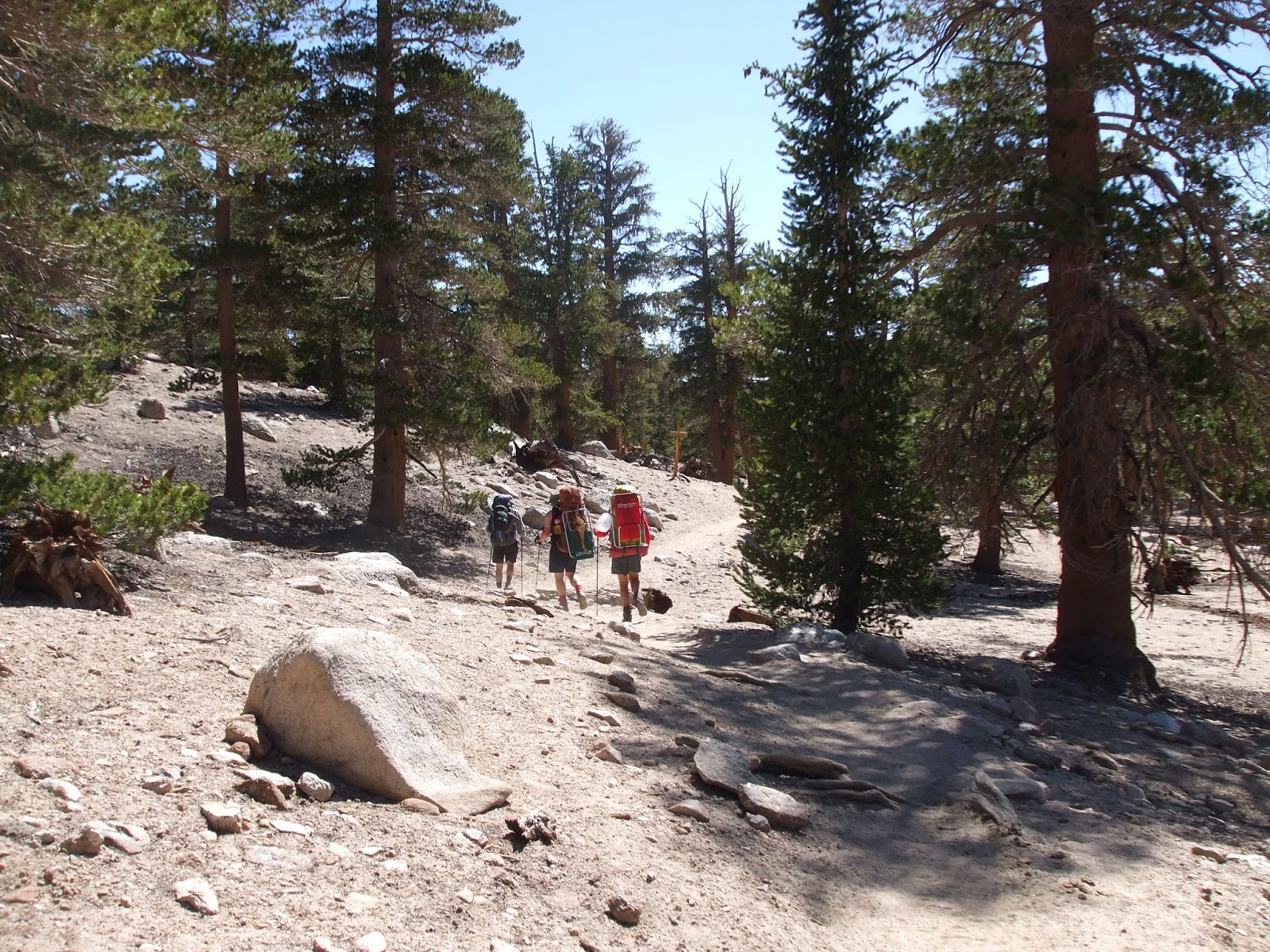
 |
| On the trail out of Miter Basin. |
Upon leaving our campsite in Miter Basin, we had several
options to reach the trail to New Army Pass. We could retrace our steps to
Middle Soldier Lake, but none of us was anxious to climb back up to the ridge
through all that sand. We could hike down Rock Creek, and pick up the trail
well down the valley by a small lake with no name. Or we could hike to Lower
Soldier Lake and pick up the small spur trail that ended there. This last
course required that we navigate along the 11,000 foot contour line and then
climb down a steep cliff to the lake level about 400 feet below. Since this
last alternative did not involve climbing up sand or hiking down an extra 400
feet of elevation only to hike back up, and also included the potential for an extremely
dangerous scamper down a cliff face, this was really the only alternative that
we considered.
 |
| Following the 11,000 foot contour line. |
The hike to the edge of the cliff above Lower Soldier Lake
was brilliant. From the open rock of the Rock Creek valley, we soon found
ourselves hiking through small meadows and a mature forest of foxtail pines.
Our already light packs were lighter still after three days of eating and
drinking, and we were feeling good about getting back on the trail. Following a
contour line is not difficult across open terrain, but it gets more complicated
in the trees and over uneven ground. We made good time until we got into the
trees, at which point we split up, each man following the path he thought best.
Without question, mine was best, although Rick probably would not agree, and
Oliver and Snow Toad would refuse to comment. Despite our fundamental
disagreements about the proper path, we all found ourselves perched atop the
cliff above Lower Soldier Lake at about the same time, each of us vexed about
the next step.
“There’s the lake,” said Oliver.
“That’s a pretty steep slope.” Rick gave voice to what we
were all thinking. “One false step and one of us could die.” Rick has a way of
lightening the mood in every situation.
 |
| Rick contemplating mortality. |
“I don’t want to die,” I said, peering over the edge. “We
should be very careful.”
“Well, if you do,” responded Snow Toad, “don’t expect any of
us to follow your example. But I think we can do it.”
With that, Snow Toad started down the slope, Oliver close on
his heels. Rick and I held back, waiting for them to get clear ahead so that
any stones we might set loose would not pummel them about the head and
shoulders. Although steep, we were able to pick our way down the mountain
without too much trouble. At one point Snow Toad climbed himself out to the
edge of a 20-foot vertical drop and had to turn back, but he was forthright
enough to announce his mistake before any of us could slam into him from behind
and accidentally push him over the edge.
From there, Oliver took the lead in climbing down. I am
always leery of following a trail that Oliver is blazing because his natural
athleticism enables him to do things that mere mortals cannot, and when a stone
gave way beneath him, causing him to glissade down a smooth granite slope for
about ten feet, I had real doubts about his chosen path. But the little chute
he had been climbing down was still the best path, so we followed carefully,
hoping to avoid his sliding maneuver that surely would have been the end of the
rest of us.
We each breathed a sigh of relief upon reaching the bottom,
congratulated one another, and in a moment of shameless self-adulation, agreed
that we were all worthy of a Billy Goat Badge. And why not? With no one else
around to celebrate our modest achievements, it was up to us to do it.
Lower Soldier Lake is a beautiful lake, set in a deep bowl
of carved granite. Like many of the places we had been, though, the camping was
mediocre. Most of the spots were too close to the water, and the best spots, down
by the outlet where the stream flowed out of the lake, were restricted for
habitat restoration. But as is frequently the case, some excellent camping
spots could be found just a short ways down the trail along the stream. Lake
camping is always nice; stream camping is often better.
 |
| Cliff of Doom from a distance. |
A little bit of success is a heady brew, and we were riding
a success high. You might even say we were feeling cocky. After all, we had
successfully followed the 11,000-foot contour line, we had successfully negotiated
the cliff above Lower Soldier Lake, and we had successfully positioned
ourselves within three miles of New Army Pass. The sun had come out from behind
the clouds, and with Lower Soldier Lake behind us, we were now hiking on level
trail through trees with an occasional view down the Rock Creek valley. With
all that sun and all that success, we could not help but anticipate clearing
the pass before storm clouds returned.
 |
| To the Pass! |
But success is also ephemeral, and 2.3 miles of uphill,
starting at 10,880 feet and climbing to 12,310, will severely tax all but the
headiest of brews. Our brews were not that heady. The trail is well graded, a
brilliant piece of engineering, really. The views are spectacular, which helps,
and the headstones, presumably honoring those that have died while seeking the
pass, are a cheery touch. But 2.3 miles is a long way to go uphill, even with
packs as light as ours. The clouds began to drift back in about the time we
started the climb, and by the time we reached the pass itself, the sky had
taken on a menacing, gray pallor. Lunch would have been welcome, but getting
off the pass was more welcome still. Unfortunately, events would conspire to
prevent us from reaching camp before the weather arrived.
 |
| Headstone. |
Rick reached the top of the pass first, and by a wide
margin, demonstrating the determination that makes Rick the man he is. If there
is a job that requires beating one’s head against a wall until the wall gives
way, then Rick is the man for the job. He does not go about this business in a
flashy way, and while he is beating his head he will tell you all the reasons
why doing so is less than optimal. But he will outlast the wall. His past is
littered with crumbled walls, his present colored by a bruised forehead. Once
he started climbing he would not stop, and for his determination, he was
awarded the Keep Pounding Away Badge.
But Rick’s long stay at the top of the pass would also make
the events that followed that much more remarkable. For one of the interesting
features of his overstuffed and misshapen pack is that for all its overstuffedness,
still not everything fit inside. He has shoes tied to the outside, and a jacket
looped under the hood, and a cup and a bell and a whistle, and just for good
measure, his sleeping bag is also strapped outside his pack. As many of you
know, the sleeping bag is a critical piece of gear, and its loss could be
uncomfortable and perhaps even tragic. But for some reason, on this one
occasion Rick neglected to check the strap tension on his sleeping bag, even
though he had plenty of time to do so. Maybe it was the elevation and the thin
air, maybe he was gassed from the climb, or maybe he was too busy eating
snacks. But whatever the case, the sleeping bag parted company from the pack
shortly after we started down the eastern side of the pass.
Oliver was out in front, as he usually is on the downhills,
and Snow Toad was not far behind. Rick and I were hiking together about a
hundred yards behind them. We were all going fast. The wind was picking up, and
we could feel the moisture rising in the air. We would get rain, and we did not
want to be out on an exposed rock face if the rain was accompanied by
lightning. So when we came to a particularly sharp switchback, Rick swung
around the corner like a driver in Le Mans, his heavily cantilevered sleeping
bag whipping through a 180 degree arc in a fraction of a second. I was hiking
behind him, and I watched in fascinated horror as the sleeping bag hurtled
through the air in its dirt-brown stuff sack, and down the steep slope.
“Rick! Stop!” I shouted.
Rick turned around. I pointed to the sleeping bag, which was
still bounding down the hillside, bouncing off rocks, and finally coming to
rest under a large square boulder, easily distinguished from all the other
large square boulders as long as we did not take our eyes off of it for a
second. So what Rick should have done is dropped his pack right then and there
and climbed down to get the sleeping bag. But the slope was very steep, and
from where we stood, it looked as though climbing up from the trail below would
be much easier than climbing down from where we were. So we did our best to
take bearings and identify features that would uniquely identify this square
rock from all of the others, and then we headed down the trail after Oliver and
Snow Toad.
Rick was pretty well panicked by the time we reached to turn
for the next switchback, and as we gazed up to the peaks to get our bearings,
we realized our error. Every square rock looked the same, the unique features
of “our” rock washed out in the completely different perspective we now had
from down below. We hastened down the trail, trying to estimate how far we had
hiked on the previous switchback, and finally, when he could stand it no
longer, Rick threw his pack off, and started climbing up the hill. His path was
random, as he slowly picked his way across the steep rock slope, looking for a
dirt-brown bag amidst a field of dirt-brown rocks.
By now Oliver and Snow Toad had realized that something was
amiss, so they pulled up and waited for us about 200 yards down the trail.
After ten minutes of watching Rick engaged in his fruitless search, I did what
I should have done ten minutes earlier: I hiked down to where Oliver and Snow
Toad had stopped, explained what was going on and opened a betting line on
whether or not Rick would find his bag.
“I don’t think he’s going to find it,” said Snow Toad.
“That’s going to make for an uncomfortable night,” added
Oliver.
“The line is now 62 to 1 against finding the bag,” I noted.
“Any more bets?”
“I like those odds,” exclaimed Snow Toad, “here’s another
dollar.” He handed me a crumpled bill. “You know, if he doesn’t find that bag,
we will probably have to hike out a day early.”
“That would really suck,” said Oliver. “Maybe we should help
him find it.”
“Give me my money back,” Snow Toad demanded. “I don’t want
to hike out early and I don’t like to bet against my own interests.” I
reluctantly handed Snow Toad his money back. I had no doubt that Rick was going
to find his bag, because he was going to comb every square inch of the
mountainside until he did. It was just one more wall that would eventually
crumble from him beating his head against it.
Rick did find his sleeping bag, but not before he had
climbed all the way back up to the trail above. After I reminded him that the
bag came off when he went around the corner, he followed the trail back up to
the next switchback, and then climbed down the steep slope to the big square
rock, just like he should have done in the first place. The whole episode had
taken at least 30 minutes, but it was not a complete waste of time. We learned
some important things. First, we learned that it is very important to tie one’s
gear securely, especially if it is a critical piece like a sleeping bag. And
second, we learned that even at 62 to 1, no one was willing to bet against
Rick’s hardheaded determination.
The weather continued to deteriorate while Rick was conducting
his search, and the rain started to fall before he finished. This was not a
hard rain, but enough to encourage those of us who were just standing around to
put on a jacket and to cover our packs. Fortunately, we did not get any
lightning, although we could hear an occasional thunderclap on the other side
of the pass. The sound of thunder is a real motivator, so we motored down the
trail until we got past High Lake, and almost down to Long Lake. Most of this
terrain was still out in the open, but we were well off the ridge and still we
had not seen any lightning on our side of the mountain.
We had hiked for about seven miles from our campsite in
Miter Basin, the last four and a half on the trail. Our goal for the night was
Upper South Fork Lake, and from the map it looked as though we could bypass the
last bit of trail and go cross-country directly to the lake. This proved to be
a bad decision. We quickly found ourselves hiking in a dwarf forest of foxtail
pines and junipers, through thorn-covered bushes while picking our way over
crumbled rocks the size of bowling balls. The rocks were sharp-edged and
irregularly shaped, so each step was a sprained ankle waiting to happen. Oliver
eventually got so fed up with our direct path to the lake that he abandoned it
in favor of a longer route through a boggy meadow on the south side of the
lake. The rest of us stuck it out a bit longer, but for no good reason, so we
eventually followed Oliver down to the meadow.
 |
| Stunted forest, thorny bushes, rocky path. |
The rain, which had stopped while we were passing High Lake,
now returned, this time with a bit more conviction. The dwarf forest had
evolved into a forest of greater stature, but the bushes amongst the trees were
no less thorny, and the ground no less rocky. The camping in the trees was just
plain shitty, and the meadow, while soft underfoot, was lumpy and increasingly
bog-like the closer we got to the lake. When we finally found a small flat spot
on the edge of the meadow that was not covered with sharp rocks, our joy was
entirely out of proportion to the quality of the site in question. But it was a
flat spot, we could have found a way to fit our tents, and we were prepared to
make do. Fortunately we did not have to. Before committing ourselves to camping
in such a lousy spot, we decided to scout out the forested area adjacent to the
lake a bit more thoroughly, and found some great camping up in the trees away
from the meadow. The site was well used, and even offered excellent access to
the main trail, just 150 feet away.
The rain came and went through the afternoon, including a
downpour for about 15 minutes. But the showers cleared before sunset, leaving
behind clean, pine-scented air, brightly colored clouds, and an opportunity to
kick back in the kitchen area while Oliver made dinner. On the menu were bean
and cheese burritos with chicken and onions fried in olive oil. Snow Toad had
ramen.
 |
| Sunset over Upper South Fork Lake. |